ArcGIS Image Dedicated is a managed software-as-a-service (SaaS) that allows you to manage, serve, process, and analyze imagery and raster directly from your AWS or Azure cloud storage. As a managed SaaS, Esri manages dedicated servers and compute infrastructure next to datasets living in AWS or Azure to help you reduce egress costs and ensure scalability.
Here is a summary of the updates we are introducing in the August 2023 release of ArcGIS Image Dedicated:
Pro Machine (Virtual machines with ArcGIS Pro)
- Define disk storage requirements for your machine.
- Access machine templates for ArcGIS Reality Studio, public datasets, and SLPKs available within Microsoft Planetary Computer.
Tiled and Dynamic Imagery (Used to share imagery)
- Create up to 50 usernames and passwords for Dynamic and Tiled Imagery Servers.
Processing and Analysis (Used to process and analyze massive imagery)
- Persist CRF and Tile Cache as part of Processing and Analysis.
Pro Machine Enhancements
In this release of ArcGIS Image Dedicated, Pro Machine users can define the additional disk storage attached to the machine(s). Image Dedicated Credits will be consumed depending on the size of the storage requested. The usage reports will have information about the storage used daily.
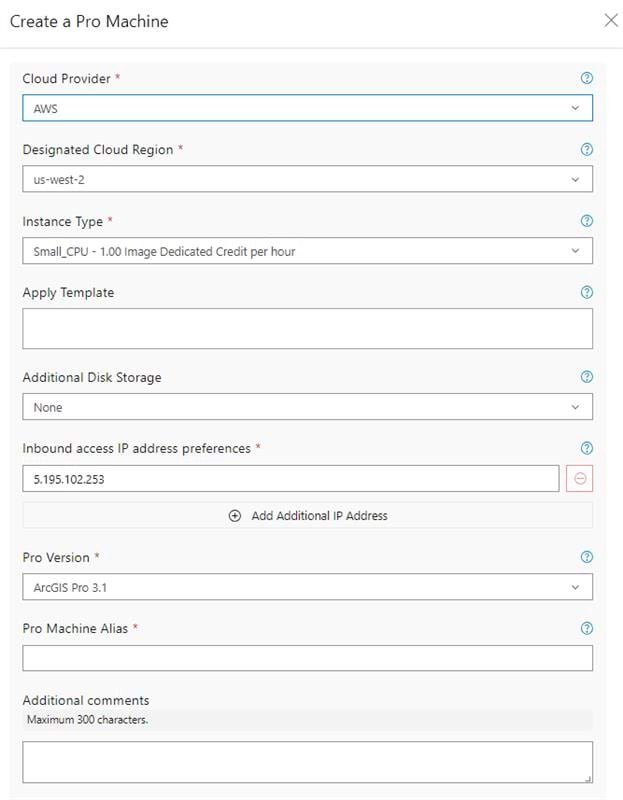
Pro Machine Templates
Additionally, as of this release, new Pro Machine templates are available:
- ArcGIS Reality Studio Tutorial – This template is added in all the regions. It provides sample data for users to learn how to use ArcGIS Reality Studio. Users can access the tutorial here.
- Imagery Workflows – This template is now supported within the AWS (us-west-2) region. This means that workflows to build Landsat, Sentinel-2, and NAIP mosaic datasets are now supported in this cloud region. In Azure (West Europe/Planetary Computer), the imagery workflow template has been updated based on feedback from various users.
- Lidar – This template is now supported in Azure West Europe to create SLPK using the lidar 3DEP data from Microsoft Planetary Computer.
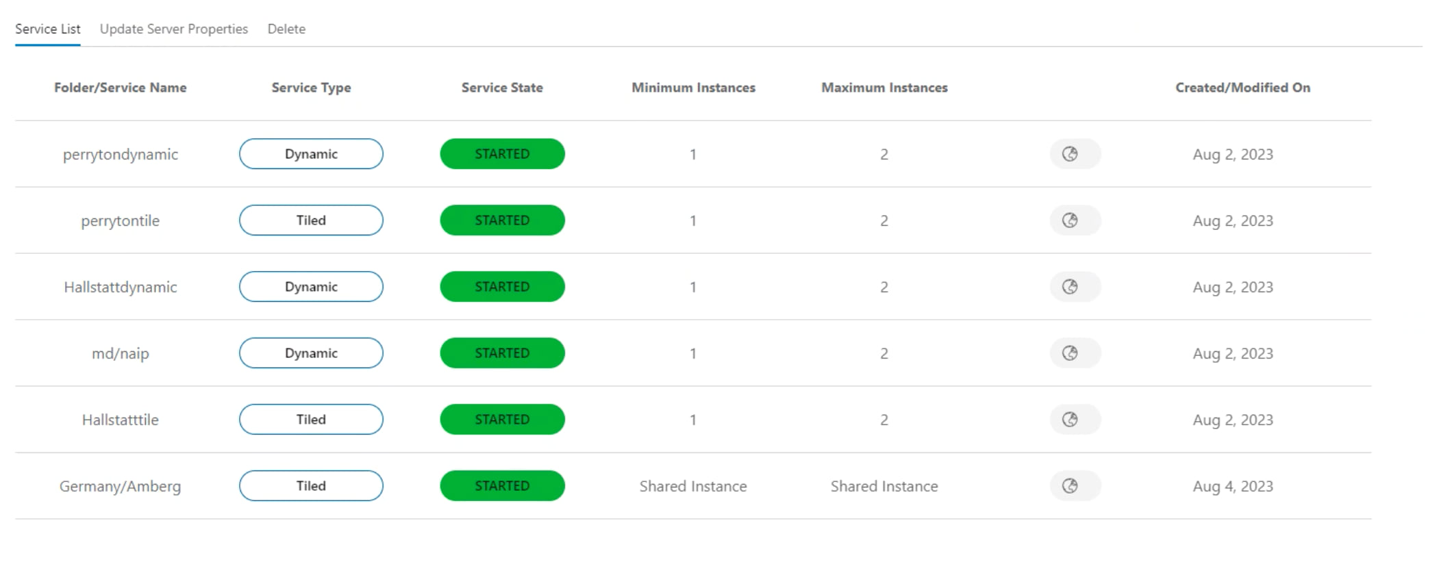
Dynamic and Tiled Imagery
This release introduces the creation of 50 usernames and passwords for dynamic and tiled image services – previously, users were only given five. The Service Management doc file contains the required documentation and scripts to set up this.
Additionally, users can custom configure the number of instances used for raster rendering and the handler services. Raster rendering services are used by tiled and dynamic image services, which are configured using shared instances. Previously, the number of instances available by default was eight, which meant that if the number of requests coming in simultaneously exceeded eight, they would be in queue until an instance became free. Now, the user can adapt the configuration based on their needs. This process is available as a script within the Service Management toolbox.
Furthermore, a new action, “Clear Rest Cache,” has been introduced in Managed Tile Services. This action can be executed when updating or refreshing tile cache.
Additional minor enhancements include the availability of Dynamic and Tiled Imagery Servers to be upgraded to ArcGIS Server version 11.1 (the new server deployed will already have ArcGIS Server 11.1), an updated order status view on the site for Dynamic and Tiled Imagery Server, greater visibility into the minimum and maximum number of instances used per service in the Image Dedicated site, and various bug fixes/enhancements to error reporting.
Processing and Analysis
This release brings an efficient method to transform a mosaic dataset covering larger areas into formats for optimal, efficient streaming. This is achieved by splitting the job to run on multiple machines and processing them in parallel to expedite completing the request.
In addition, a new tool has been added to Persist Imagery in tile cache format. This enables a mosaic dataset that references a large collection of images and defines any form of processing to be persisted as a tile cache to be published as a tile service.
Finally, we’ve added additional content providers who can now use the Transfer File tool to process and move data efficiently into a customer’s ArcGIS Online.
Want to learn more?
Check out our resources below to help you get started:


Article Discussion: